
Having had my fill of thick Juniper Trees from a couple of weeks ago and feeling somewhat tapped out on the peaks in the Silver Peak - UT quadrangle, I set my sights on the Black Mountain Range that divides the long climb out of Cedar Valley before dropping into Minersville proper. I have fond memories of this drive back when fishing had seasons. My father and I would make the drive after he arrived home from work, pulling our little fishing boat to the ramps of Minersville Lake. Now a state park complete with campground, we often slept along a dirt road, on cots with sleeping bags. I remember mosquitoes bites and long spinning fishing lures as we trolled around the lake. We were often catching our limits before noon.
I turn left onto a dirt road which I had previously marked on GPS and began to follow the rocky path toward Peak 7460. Peak 7460 is accessible by high clearance vehicle, and I doubt if 4x4 wheel drive is needed. The peak is distinctive with communication towers residing on the summit, and a substation is also near.

Unnamed Peak 7460; Iron County; Baboon Peak - UT quad; Rise 320’; UT Rank: 1,836
Peak 7460 is also distinctive for me today as this will be my first ascent in this quadrangle. Both Dry Willow Peak quadrangle and Baboon Peak quadrangles are new ascents for me today. As I move toward the towers, I notice occasional movement on the road, to small for a rodent, to large for a bug. As I spot another one I slow down and stop, getting out of the jeep, I am surprised to find a "Mormon Cricket" in the road.

Mormon Cricket
About the size of my thumb, these insects look black or dark, dark green. Seeing one or two crickets alone is not bad, but it would be horrific to see them together in vast numbers as our pioneer ancestors had to deal with them. It's the first mormon cricket I have seen in years, and I'm glad they are here on the outskirts of the valley.
A final ramp of about 50' feet allows me to drive the jeep to the graded top and communication tower complex. It is the steepest part of the road, and there is not much room on the summit. I park next to the fence and make my way around the southern point marking the summit. The highest spot is probably inside the wall, and the GPS summit location is off the human-made hill. I mark a place near the fence and call it a summit.
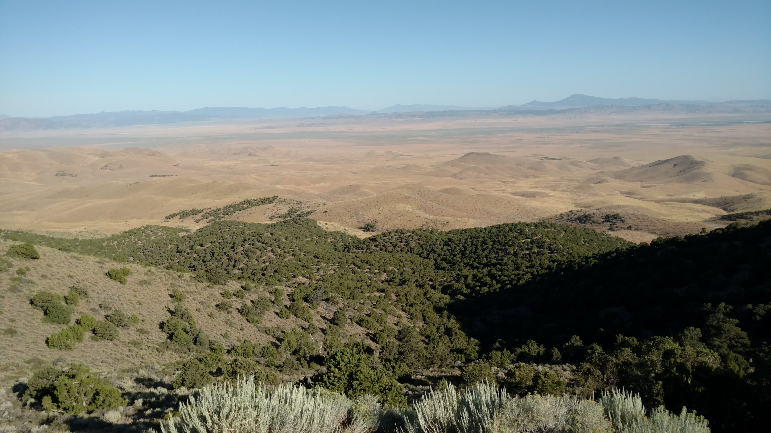
Peak 7460 summit view north
As stunning as the view is the most remarkable image is the rolling hills of brown grass. It was an extremely wet spring, and tall green grass was evident everywhere, now at the end of the dry, hot summer months, the tall brown grass is somewhat scary to look at with such a high fire danger present.

Dry Willow Peak; Iron County: Dry Willow Peak - UT quad; Rise 1,053’; UT Rank: 1,715
I make a tight 3 point turn on the summit and drive back down the main road. Not far is an intersection which will take me toward Dry Willow Peak. As I cross the razed section of land, two things are evident. First; many more crickets are present in this section. Some groups cluster on bushes to the point the plant looks black. Second; the dry grass is tall and rubbing against the underside of my very hot engine block. I follow the road to the high saddle at the base of Dry Willow Peak. I opt to park in the street, near a Juniper tree where the ground is devoid of grass, to park anywhere else runs the risk of the dry grass staying in prolonged contact with the hot points on my vehicle. I figure it is incredibly remote that anyone else will pass this way in the next hour, and if they do, then there is plenty of room to move around me.
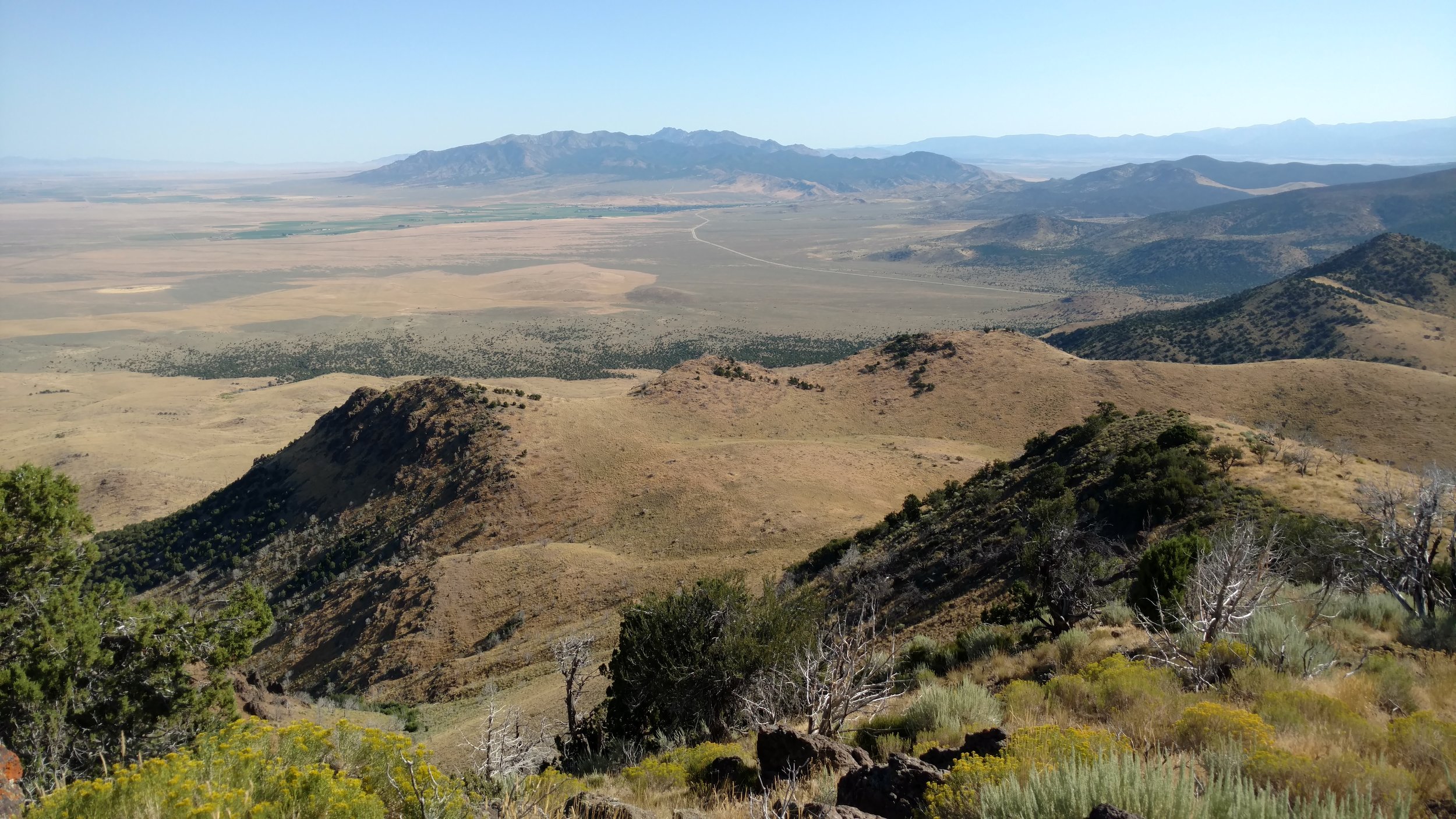
Dry Willow Peak summit view north toward the town of Minersville - UT
It's 9:30 am as I start my hike toward the summit. A road cut into the hillside leads up the mountain, and I follow a well-worn cattle trail up to the first switchback. The route tracks back along below the summit ridgeline and comes to an end. I'm about to double back when I spot a path up the hillside to the summit. I'm not the only one to follow the road thinking it will lead to the summit. It's not a long path, and the summit ridgeline contains large lava rocks. I find one near the summit and sit down to admire the morning sun, eat a snack, and drink some water. Stunning.

Dry Willow Peak summit view southeast toward Cedar City - UT
Still sitting in the morning sun, it is starting to get warm. I glance back toward Peak 7460 and spot unranked Baboon Peak to the left.

Baboon Peak; Iron County; Baboon Peak - UT quad; Rise 290’; UT Rank: unranked.
It will probably take longer to drive to the base of Baboon Peak that it will take to climb it, but I head off the summit anyway. I don't follow the worn path back to the cattle trail but opt instead to head directly off the southern face, expecting to drop down onto the road soon enough. I don't calculate the drop in the trail as I make my way down and eventually have to check my GPS track to make sure I'm not wandering too far off the face. It's only a few feet away, but I come out directly at the switchback, and I was so focused on staying on the road, that I missed this obvious path.
I have to drive back to the main junction before turning west to reach the intersection for the Baboon Peak road. This road will allow me to attain two summits which I hope to complete before I end for the day. The trail is good until I pass a cattle pen and water hole. Someone had a significant problem with mud in this semi road/wash ravine. A wheel well, filled with rocks and limbs that would still make my jeep bottom out, stretches along one side for probably 20' feet. I'm narrow enough that I'm confident I can bypass on the right-hand side. I'm able to do so, but someone had a pretty difficult time escaping the mud. I'm driving along the base of Baboon Peak and wait until I can find another bald spot in which to park.

Baboon Peak summit cairn
It's a short 20 min hike to the summit of Baboon Peak, and I'm surprised to find a summit cairn and registration bottle waiting for me when I arrive. Last signed in May of 2011 and the most common notation is not a single Baboon was spotted on the hike. Surrounded by Juniper Trees, the summit held a limited view off the peak, so I make short work of the ascent and head back toward my waiting vehicle.
The road ends in a few hundred feet in a large area covered in tall, dry grass. The location is called Baboon Seep and marks the beginning of several wash ways which drain northwest vs. south. Peak 7249 rests on the other side of the seep, and I plan to make a round-about approach following the hillside to a high saddle trying to avoid dropping down too far in elevation.

Unnamed Peak 7249; Iron County; Baboon Peak-UT quad; Rise: 309’; UT Rank 2048
I quickly find plentiful game trails, and I move horizontally following the contour of the hillside. Before long, I spot two large Mule deer as they walk between the Juniper trees and onto a reasonably open hill. The first is a large 4 point buck. It's been years since I've hunted, but just the sight of the massive rack gets my heart beating. The second is also a buck, younger with what would still be considered an impressive stand. I admire the deer from my position watch as they move between the trees. There are gullies, trees, and it doesn't surprise me that I never see them again.
At the high saddle, I turn west and move up the eastern side of the Peak 7249. More lava rock dots the hillside and I reach an elongated crest ridge. North of the actual peak, I spy a cairn. It isn't large, and it isn't at the summit, so I look around to see if it happens to be a geocache. I don't see any markers, but it has a better view, and I sit down for a drink and snacks.

Peak 7249 non-summit cairn
I gaze west at a combination of rolling hills marking the high point, and the farthest point in the quadrangle know as Mound Mountain.

Peak 7249 summit view west toward Mound Mountain (rolling brown hills picture right) with Badger Peak, Twin Peaks (north and south) and Monument Peak further out.
I'm finished hiking for the day but hope to complete Baboon Peak - UT quadrangle next week with the summits of Ladybug Benchmark, Peak 6820 and Mound Mountain.