
It’s always a little frustrating when all the research and time spent mapping out a summit approach end for naught. The small dirt road next to the gravel pit on Minersville Highway didn’t exist. A second small dirt road exited left a few seconds later, so I decided to exit and take a closer look. The trail is extremely rocky, and I have driven considerable ways before I consult my GPS again. Not even close, to the road I am hoping to locate, but there is hope, a four-wheel-drive trail connects at the end of my current route to the way I seek. I reach the end of the trail, and it is a dead-end, no extension, no connection. I turn around.
I’ve now wasted an hour, and I enter again onto Utah Hwy 130 northbound. I’ve been hiking in this area the past couple of weeks, and I am familiar with an alternate loop to reach my destination. I have yet to travel the back roadway as far as I need to go. But the road is in good condition, and I feel confident it will take me in the general direction I need to go. Hopefully, the connecting routes exist on this side of the mountain.
The long extension route is in excellent condition as I drive on the northern side of the Ladybug mountain range. I am rounding what is referred to as “Little Horse Valley” with water well and corral. The route exists on this side of the mountain, and I turn east up the rocky trail. I’m following the road, but I’m not entirely sure it is the route I need to arrive near Ladybug Benchmark. The trail is heading due east up along the foothills and finally turns south along the ridge. At least I am finally heading in the correct direction. The path climbs through standing Juniper Trees and drops into deep ravines. Finally, the road comes to an end on a small ridge about midway up the mountainside.

Ladybug Benchmark; Iron County; Baboon Peak - UT quadrangle, Rise: 664’; UT Rank: 2,121
I find a bare patch of ground to park my jeep, to avoid having the dry grass in prolonged contact with the hot parts of the vehicle. Picking up an extra water bottle, I hike the ridgeline to the summit. The air is still fresh in spite of my delay, but today is expected to warm to 90 degrees, and it won’t stay fresh for long. I wander the summit area in search of the GPS coordinates, before returning to the high point to gather actual coordinates of the peak. I’m about to take the readings when I notice a geodetic survey arrow marker pointing south through a large Juniper Tree. I round the tree and find the tag cemented into a rock. I’m not familiar with the different types of survey markers, but I note the date of 1938 and that this particular survey is a triangulation marker.
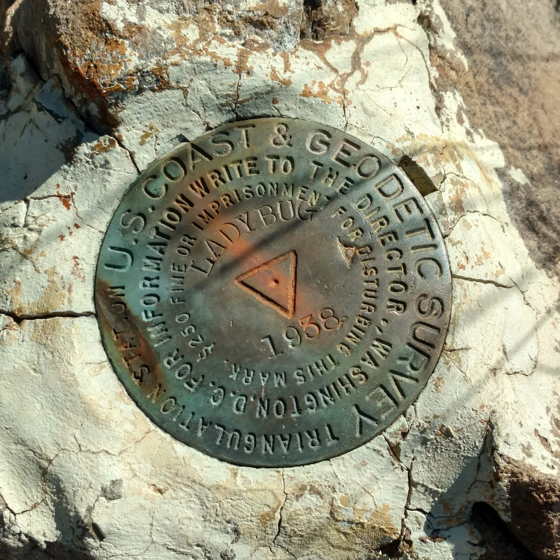
U.S. Coast & Geodetic Survey marker
The sky is crystal clear blue without the usual haze of fires we often see this time of year. Ladybug sits at an elevation of 7,177’ feet, and I marvel at the view from the summit.

Ladybug summit view north
I return along the same ridgeline, retracing my steps to return to my jeep. Along the way are deep green scrubs that my Grandmother often referred to as Brigham Tea bushes. The early pioneers would pick the long stems and seep to make a tea. My Grandmother swore by the drink for all kinds of cures. I have seen the bush throughout my hikes here in southern Utah, but I have never seen any as deep green and healthy-looking as these. I clip a few branches to see how the tea will taste.
My next destination is an unnamed peak on the western side of Little Horse Valley. Turning left on the main road, I stop to open and close a gate entering a fenced area surrounding unnamed peak 6820. The rules of backcountry driving are simple. Leave the gate as you found it. I drive west along the path until I come to an intersection, it is supposed to be a 4-way section, and I am to continue west to the high saddle. Again, no route exists. I turn left and park in the middle of the road to still avoid tall, dry grass prolonged exposure to my hot engine block. This area is a wildfire waiting to happen, and I don’t want to be the cause. I take my pack and begin the short hike to the peak.

Unnamed Peak 6820; Iron County; Baboon Peak - UT quadrangle; Rise 280’; UT Rank: unranked
From the Juniper tree-covered summit I can see my next destination and final summit of the Baboon Peak - UT quadrangle. Mound Mountain, is a series of ridges that rise to a common point. Although it is a ranked peak with a rise of 346’, the traverse will be a long hike, through the tall, dry grass in full sun. It is getting hot, and my determination to climb the final peak is waning.

Unnamed peak 6820 summit view of Mound Mountain (brown grass covered knoll)
I return to my jeep and make a U-turn to head north. I find another gate which I open, and I park in the shade of a large Juniper Tree to eat lunch. The flies are bothersome, and I have to keep my windows shut, but I leave the air conditioning on to compensate for the lack of air movement. I decide to drive to Mound Mountain and finish the task. Finishing lunch, I connect with the main road that leads into Horse Valley. I’m driving on the main route when I pass a cattleguard with a faded sign. I stop to try and read the sign and can barely make out the words “No Trespassing.” I’m confused as I believed this to all be public land, and I’m driving on the only main route through the area. The sign, however, is all that is needed to crush my already weakening resolve to climb Mound Mountain. I turn around with the determination to add Mound Mountain to my list of peaks in the Badger Peak - UT quadrangle when I return.