
I've toyed with the idea of starting a website entitled mile-by-mile and logging hikes, peaks, slot canyons, and any other cool thing to see mile by mile on every highway. My only reluctance is having to have an open site because there is no way a single person can find and verify every mile of road. Spammers tend to take over free sites and have ruined many a good website with their promise of weight loss or car warranty offers. But if I did open such a website, Utah highway 89 around Kanab would be a great place to start.
Linda and I turned right onto highway 89 at the junction of Highway 14, known as Tod's Junction. One of America's Scenic Byways, the road twists and turns following the east fork of the Virgin River through small towns and shaded campgrounds. The sleepy nature of the little valley lends to its appeal, as we make our way south. Usually, these campgrounds are overflowing with trailers and tents, but of the open campsites, only a camp trailer or two are present. Most of the world is still in lockdown due to COVID-19, and we have been extremely fortunate to live in this sparsely populated area. Tourism has taken a dramatic downturn, and it is evident by the lack of cars. Buses that usually transport thousands of visitors daily between Zion National Park up this scenic byway to Bryce Canyon are absent.
I grabbed a half-dozen small brochures and tourist maps from my drawer, thinking if we saw some of these short and easy locations, without a lot of people today, it would be a good day to do so.
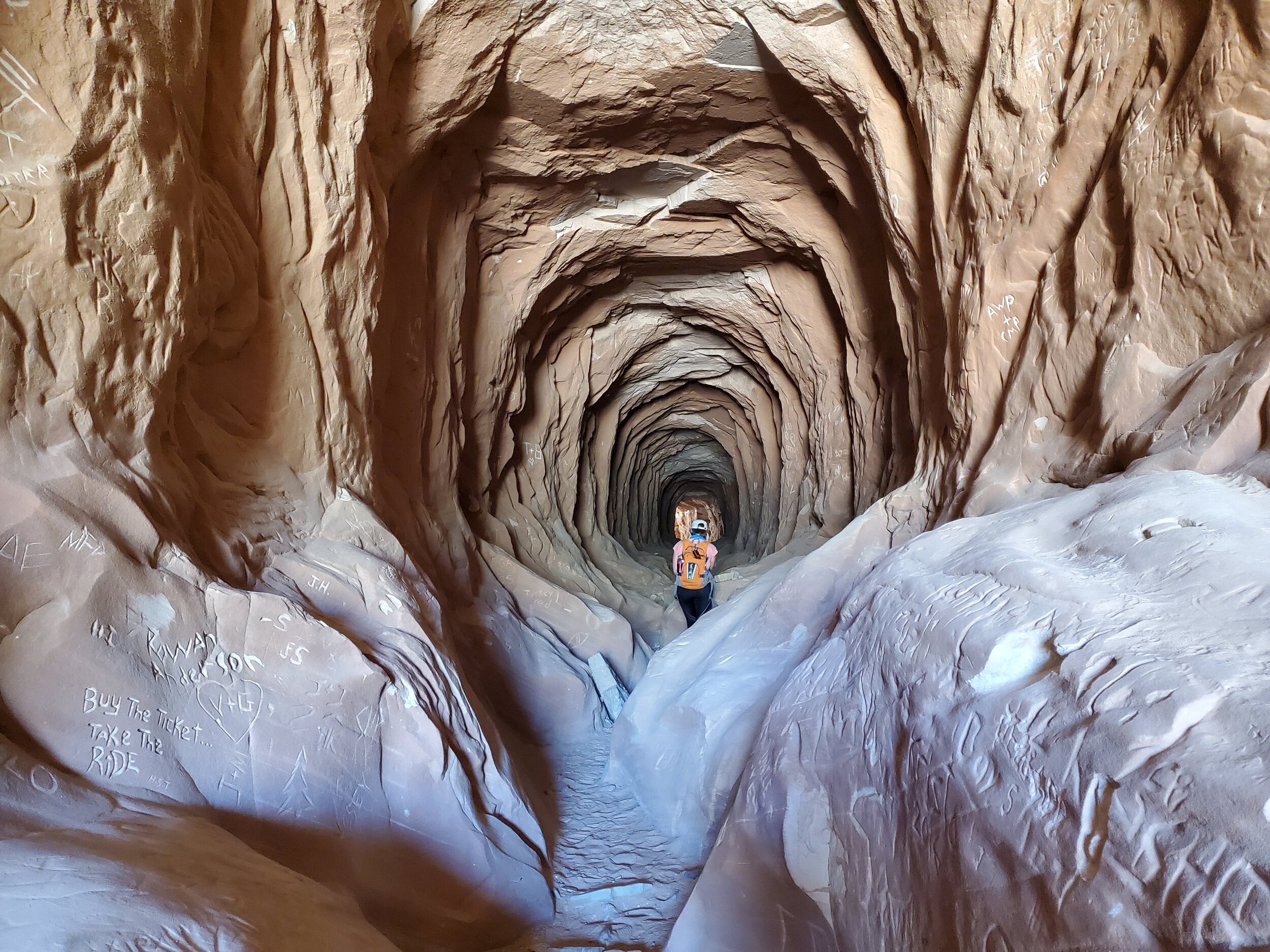
Belly of the Dragon
First up, Belly of the Dragon. According to the Kanab Visitor's page entitled Kanab Magically Unspoiled, the Belly of the Dragon is composed of a "carved tunnel that goes under Highway 89." That doesn't sound like much, but I have seen pictures, and I was itching to see it myself.

Belly of the Dragon
Not long, the conduit has been in existence for some time. Water has continued to erode the bottom of the tunnel into a mini slot canyon as massive amounts of the water during the rainy season, continue to drain from the upper canyons through this tunnel on its way to the North Fork River.
It's almost hard to see, and the hole in the hillside is relatively unassuming. A small parking area exists near the entrance, and I wouldn't be surprised to find a large number of ATV's in the lot. A few camping vehicles are in the area, but only a single truck is present. The approach hike is probably 50 feet at best, and a cement spillway makes for an awkward downclimb into the tunnel, but the sight is worth every step.

Graffiti
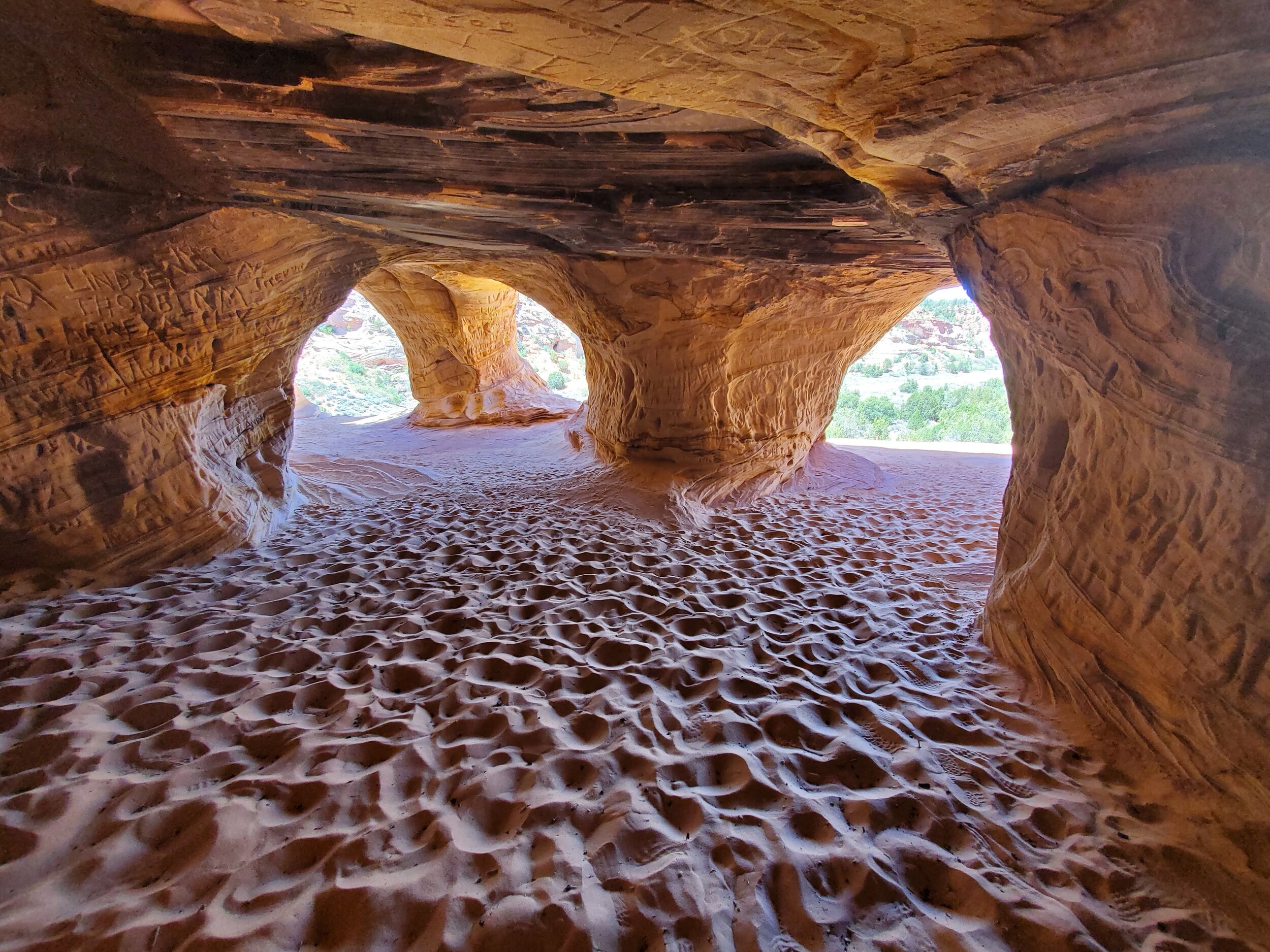
A few miles further down the road, we pass the turn off for the Utah State Park Coral Pink Sand dunes. We are going to come back to this point, but for now, we are looking for the Moqui Cave and the Sand Caves that exist just a short distance away.

Sand Caves
I never knew that these caves were human-made until I read the brochure. But somewhere along the way, someone thought that "mining for the sand in the area" could be a profitable venture. I'm not sure what type of sand they felt they could mine versus the kind of sand that ran down the wash below, but apparently, they punched a lot of holes in the area before abandoning the endeavor.

Sand Cave windows
A well-worn hiking trail leads to the base of the cliff band that the caves exist on, and if one is comfortable with steep Slickrock ascending at this point is possible. We opted to hike along the trail, climb the dry fall, and follow the trail hike back to the awaiting caves.

Beautiful color
The caves are stunning in their beauty. The stone is once again marked and pocked by graffiti. Openings allow light in creating a mixture of shadow and rock, which is mesmerizing to the senses. A sandy floor exists as we wander from window to window looking down on highway 89.

Linda looking out small window
I have often seen these caves and people hiking the short distance to view them, but I was usually on my way to something I thought was more exotic. I'm glad I finally took the time for a visit.
Sand Caves
Linda and I decided to downclimb the steeper section and follow a small rib line to the bottom. The short cut probably saved us 10 minutes of hiking is all, but I'm glad to be back at the jeep for a drink of water.

Monument Knoll; Kane County; Mount Carmel-UT quad; Rise: 200’; unranked
Our final destination is a small drive down the Coral Pink Sand Dune park road to a little unranked peak known as Monument Knoll. Our elevation is higher than one would expect in this Southern Utah desert environment as we pull to the side of the road. Our tires sink into the soft sandy shoulder of the road as we mentally map our way through the tall sagebrush between the road and the peak.
A beautiful slab of slick rock covers about a third of the rise, and we hike up the colorful ribbed slab of sandstone. Stepping off the rock onto the soft sand and our progress slows to a crawl, well, my pace slows to a crawl as I stop to catch my breath. Linda's lungs are still acclimated to the 10,000-foot elevation of Brian Head resort and politely stops to wait for me. We follow game trails through a series of sand type dunes to arrive at the summit. A large cairn awaits us at the top, and Linda points to a road on the south side that leads right to the base of the hill. It must be a famous climb for those staying in the campground not far from here.

Summit view south and road to base of knoll
A plague is attached to the most massive bottom stone of the cairn, and the writing is difficult to make out, so we take a picture and hope to read it later. The plague is intriguing and gives a history of the area and why this little mountain was essential to the settlers in the area.

Family plaque describing monument knoll and it’s use to early settlers
Isaac Edwin Black as sheepherder for the United Order built this monument during the winter of 1874. Here he left messages as to his camp location for those bringing him supplies. This is one of several monuments in this area. (unknown word) by Allen Clarence Black and Family June 17, 1982.
Tired, we drive back along highway 89, then turn onto Highway 9 through Zion National Park. The park is closed to parking and hiking, and I tell Linda as we drive through the empty park that this reminds me of the Zion of my childhood. Bright and clean, no cars, and very few people. We stop for dinner at Oscars, who only today reopened their patio dining area. Wearing masks with about half the tables removed, the staff did a fantastic job of making us feel welcome. I sincerely hope this is not the "new normal."