
It’s a beautiful morning as I park my Fj at the trailhead to Zion’s West Rim Trail. The temperature is moderate for July, but at this elevation, the nights are cold in spite of the surrounding desert park. The temperature will reach triple digits in the main canyon below, but I hope to be out of the park before the intense heat arrives in the late afternoon. I brought hot weather gear, my water filter pump, and verified that the two springs along the trail are flowing (information available and updated regularly via the backcountry desk).

High country trail
There is a slight breeze on this high mountain plateau as I walk among the ponderosa pine trees, the temperature while in the shade of these massive trees makes me wonder if I should have kept my light jacket on instead of leaving it in the jeep. I’m making good time, in this constant downhill trail, and soon views of Greatheart Mesa begin to break through the trees.

Ram’s Peak and Greatheart Mesa
I have mixed emotions about Greatheart Mesa after reaching the summit in 2014; a brand new hiking pole resides near the plateau’s edge, having been left there by me on my descent. The descent required a handline rappel, and I pulled the rope before recognizing I didn’t have all my equipment. The second pole served me well for several years as a solo walking stick, but I have since replaced it with another pair of poles. I like the duel pole method better. As the trail rises in elevation, there is a stunning view down the canyon, I am mesmerized by the beauty of this rugged backcountry.

West Rim Trail View Southwest
The trail soon descends into Potato Hollow, and the first water spring is nearby. I check my water supplies and decide to move forward. The temperature is rising, and the breeze has disappeared in the valley of tall grass. I am surprised that no one is camping at the #8 campsite, which I have always heard is preferred to the other sites.
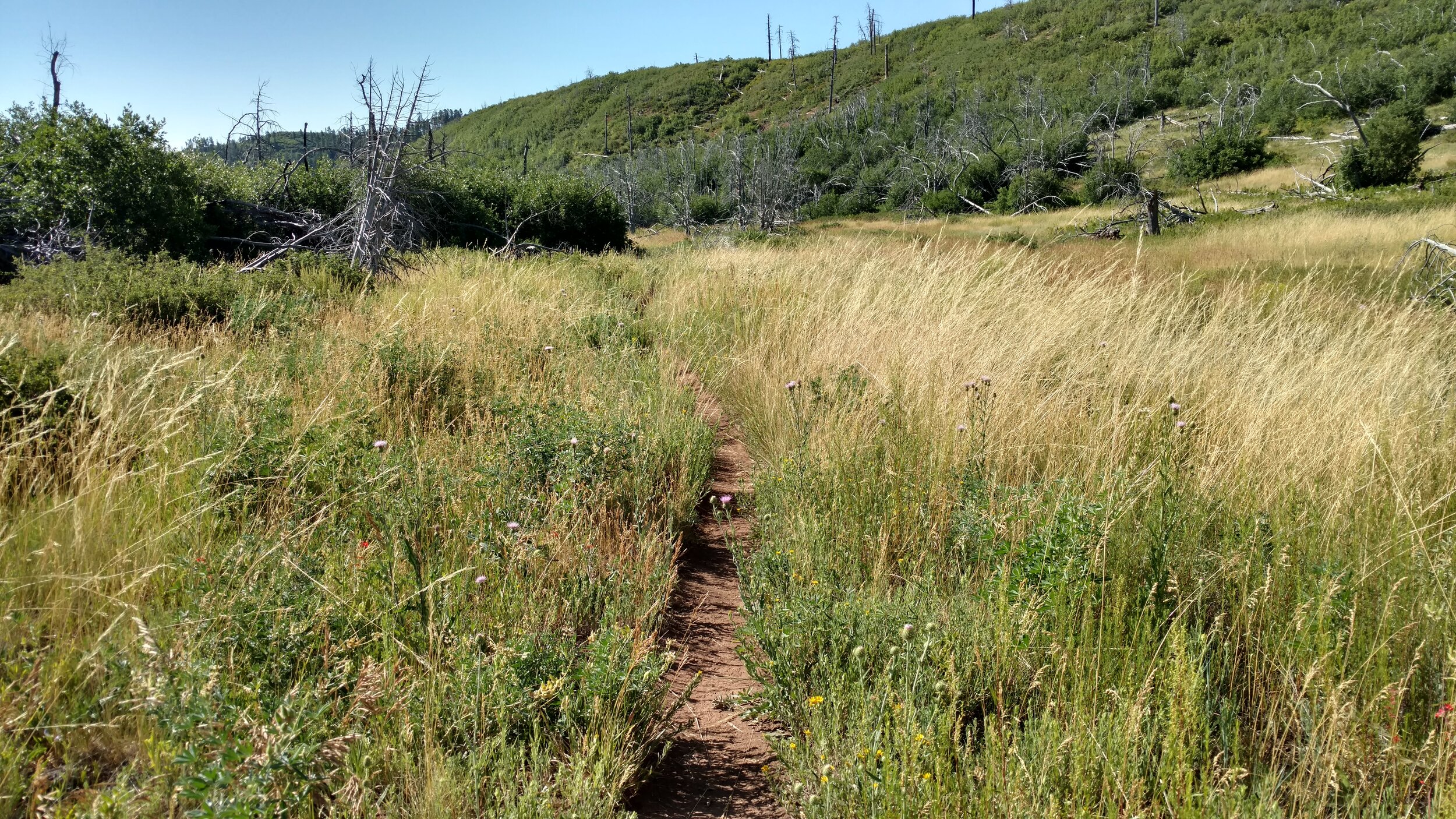
Potato Hollow trail view
The tall grass nearly overgrows the trail, and there is ample evidence that spring is gone and the summer months are taking their toll. It won’t be long before this valley is nothing but brown weeds. Dead trees are a good indication of previous wildfires having swept this plateau in the past. The trail begins to rise, and I have started an ascent of the eastern face of Never Done Mountain. Two ranked peaks exist along the West Rim Trail, and reaching the summit of each is my reason for the long day hike today.

Summit View from Never Done Mountain; Washington County; Temple of Sinawava - UT quad; Rise: 355’; UT Rank 1924.
I’ve mentioned before the book: Zion National Park: Summit Routes by Courtney Purcell. I especially like his etymology about this peak.
While on the summit one day, my partner Andy Archibald commented on how the views inspired him to explore more and more of Zion. Instead of the same reaction, the views reminded me of how much more I still had left to do in the park. Andy then coined the name “Never Done” for the Mountain. Ha!

Summit View Never Done Mountain
It’s now officially hot as I reach the junction in the West Rim Trail. Staying to the hikers left will make a more direct route following the wash of Telephone Canyon, the trail cutting across the plateau. I turn right to follow the trail along the rim. Horse Pasture Plateau summit sits just off the path, but the rim route adds considerable distance to an already long day. I’m becoming concerned about the time. Due to the one way nature of the hike, my wife Linda, is going to meet me at the visitors center around 5:00 pm. With no cell phone reception, I have no way to contact her if I’m running late. One thing is for sure, the views along the rim make the additional time breathtaking.

Summit View from Horse Pasture Plateau; Washington County; Temple of Sinawava - UT quad; Rise: 375’; UT Rank: 1917.
I’m so enthralled with the landscapes that I very nearly pass the summit of Horse Pasture Plateau. The actual summit resides just a few dozen steps off the trail, and the view is spectacular.
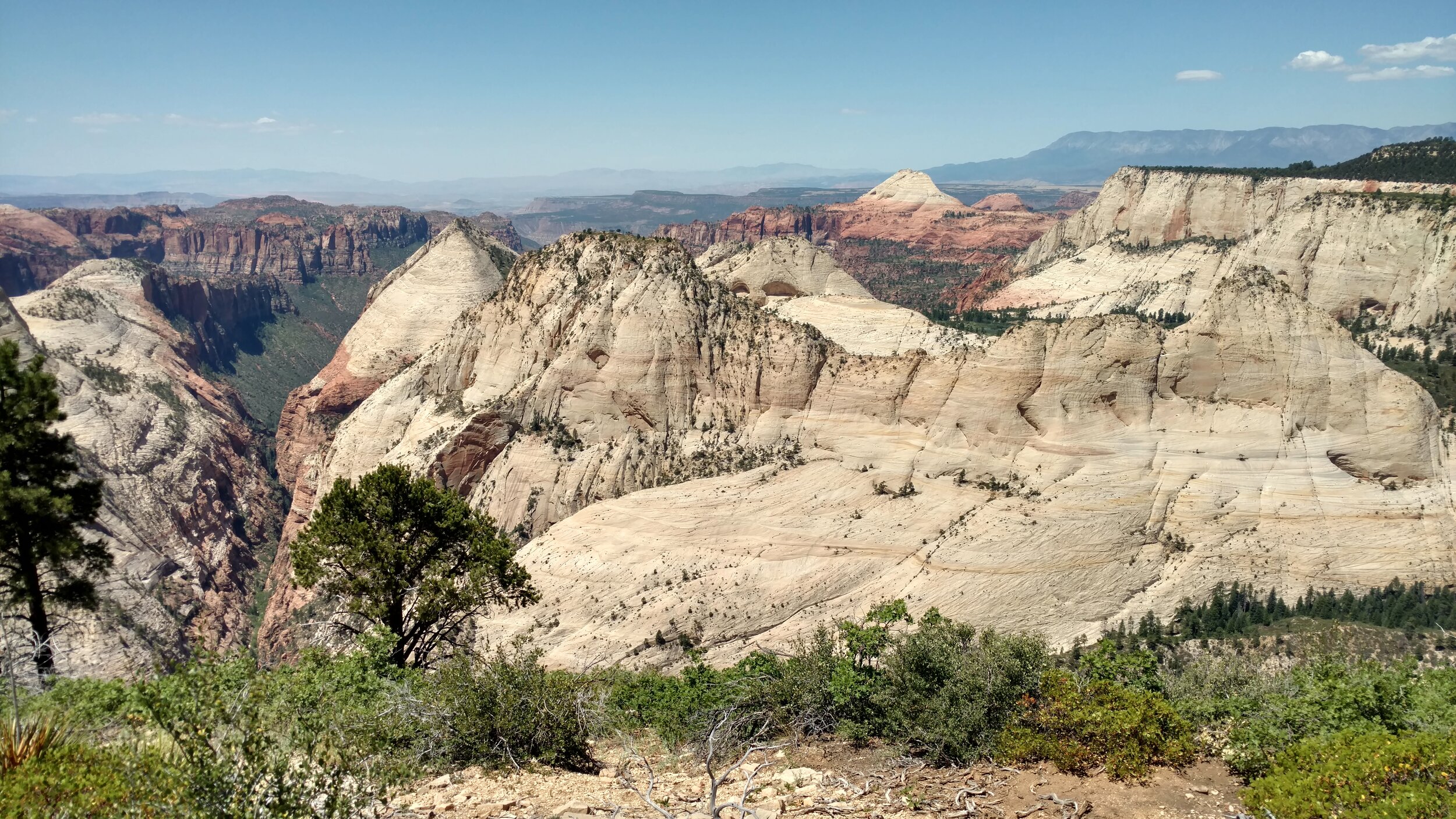
Summit View southwest
I take a break under the shade of a tree and eat a snack. I’m way behind schedule. I’m hiking slow, or I have underestimated the time it would take me to walk this distance. I’ve enough experience hiking to have a pretty good idea of my pace, so I am more than a little confused about why I am running so late. I’m more concerned about Linda making the drive and having to wait a long time in this heat. I finally arrive at Telephone Canyon Springs and I am greeted by another thirsty hiker. The mule deer isn’t shy, and I’m grateful to refill my water supply. I’m out of water and have been for the past hour. The spring is flowing, but it is nothing more than a trickle.

Mule Deer near water spring
Filling a couple of bottles of water from the spring, I get my hot weather gear out and give them a good soaking. My equipment consists primarily of a towel, which, when wet, is efficient in evaporating, creating a cooling effect. The temperature is well into the 90’s here on the plateau and will rise as I hike down into the canyon. There is very little shade along this section of the trail and I haven’t seen another soul all day. Every campsite along the rim was vacant. Standing near the short path to the spring, I look at the information sign and see why I’m running late. This sign marks the mileage I expected to hike. The trail beta I consulted must have broken the trail mileage into two sections. The plateau as one section and the canyon as another, taking the two combined, will add about another hour to my hike.

West Rim Trail
The West Rim Trail connects with Angels Landing Trail at Scout Lookout point. It’s hot, and I’ve spent the past hour moving between, and resting in what little shade I could find. Draping my wet “cooling” cloth around my neck and letting in dangle onto my chest. Every inch of shade has people resting under them when I reach Scout Point, and I breathe a sigh of relief as I drop down Walters Wiggles into the cool of Refrigerator Canyon. The Grotto shuttle stop is a hub of activity as several ambulances are present, and park rangers are helping heat-induced victims cool their bodies down. I exit the shuttle stop and catch sight of my lovely wife circling the parking lot. The concerned look on her face begins to evaporate as I step to the curb. Air conditioning never felt so good.