
Another beautiful Friday morning as I head out the door. It was 37 degrees last night and currently sitting about 42, I think briefly about bringing a jacket, but I don't as I know it will warm up fast. There is no wind blowing and not a cloud in the sky.
I'm heading back to the same area I hiked in last week, the mountain range known as Wah Wah Mountains west of Minersville and Milford. There are some impressive peaks in this mountain range, but so far I am just working my way through the low lying peaks, getting to know the roads and which ones are better for travel. It takes time to get to know an area and nothing delays a day hike faster than a rough way or worse yet a non-existent path where a map highlighted one. When it comes to the more massive peaks, such delays can cost you the summit.
Just past Minersville, I turn west on an asphalt road leading to various farms and many of the Smithfield feed stalls for their pork production. Jockey Road which I accessed from the Lund area last time is a maintained gravel road, but unfortunately, the pavement ends just beyond the Three Peaks area and is a long drive even on a maintained byway, this approach allows me faster access by driving on pavement most the way. As I finish up these foothills, it won't make much of a difference which way I enter from, but getting to know the roads is helpful.

Dead Horse Point - UT, Beaver County, Thermo Quadrangle, rise 95’, unranked.
Dead Horse Point is an unranked peak sitting at the juncture of the paved road, and another maintained byway leading to Milford. It is a grouping of small hills known as the Shauntie Hills. There are more impressive peaks in the Shauntie Hills area, but Dead Horse Point is the only one listed in my research. The grass is still dry, and the fire danger high so I opt to park on a used gravel site and walk versus driving on the grass-covered trail to the north.
Upon returning, another individual has parked on the gravel site. He was hunting Antelope and was hoping I would show him where I have seen some. We looked at his map, and I pointed out where I have seen some small herds in the area. He thanked me, and I headed on my way. Making the rounding turn around Dead Horse Point and exiting on to Jockey Road, movement catches my eye, and a beautiful Antelope is staring at me from the tall grass. I smile and wish him the best of luck.
Two of the roads I had highlighted on my map for travel don't exist. I follow another to a fence line, before turning back to Jockey Road determined to find a better route around. I pass one of the minor knolls I had planned to check off, but I was so totally engaged in trying to find another road I missed it. After spending more time than I would have liked looking for routes, I finally decided to see if I can reverse the loop I had intended to make and was finally able to locate a solid road leading to peak 6139.

Unnamed Peak 6139, Beaver County, Blue Mountain quadrangle, rise 349, UT Rank 3386
Peak 6139 has an extended southern ridgeline and is boxed in by roads on all four sides. I traveled down the eastern side road and turned into a large gravel wash on the south side. Finding a good entry point, I decided to hike the long southern ridgeline instead of wasting more time trying to find a closer parking spot. The ridge is made up of rocky terrain and Juniper Trees. It's not a strenuous hike or particularly tricky, and the summit contains a cap of twisted rock with stunning views in all directions. As typical, the summit coordinates are incorrect as I find the highest point and take a break. It's a beautiful day, there is very little haze remaining from the fire just southeast of here in the Black Mountain Range over the past week, and a cool breeze blows up the ridge making it pleasant even as the temperature is increasing.
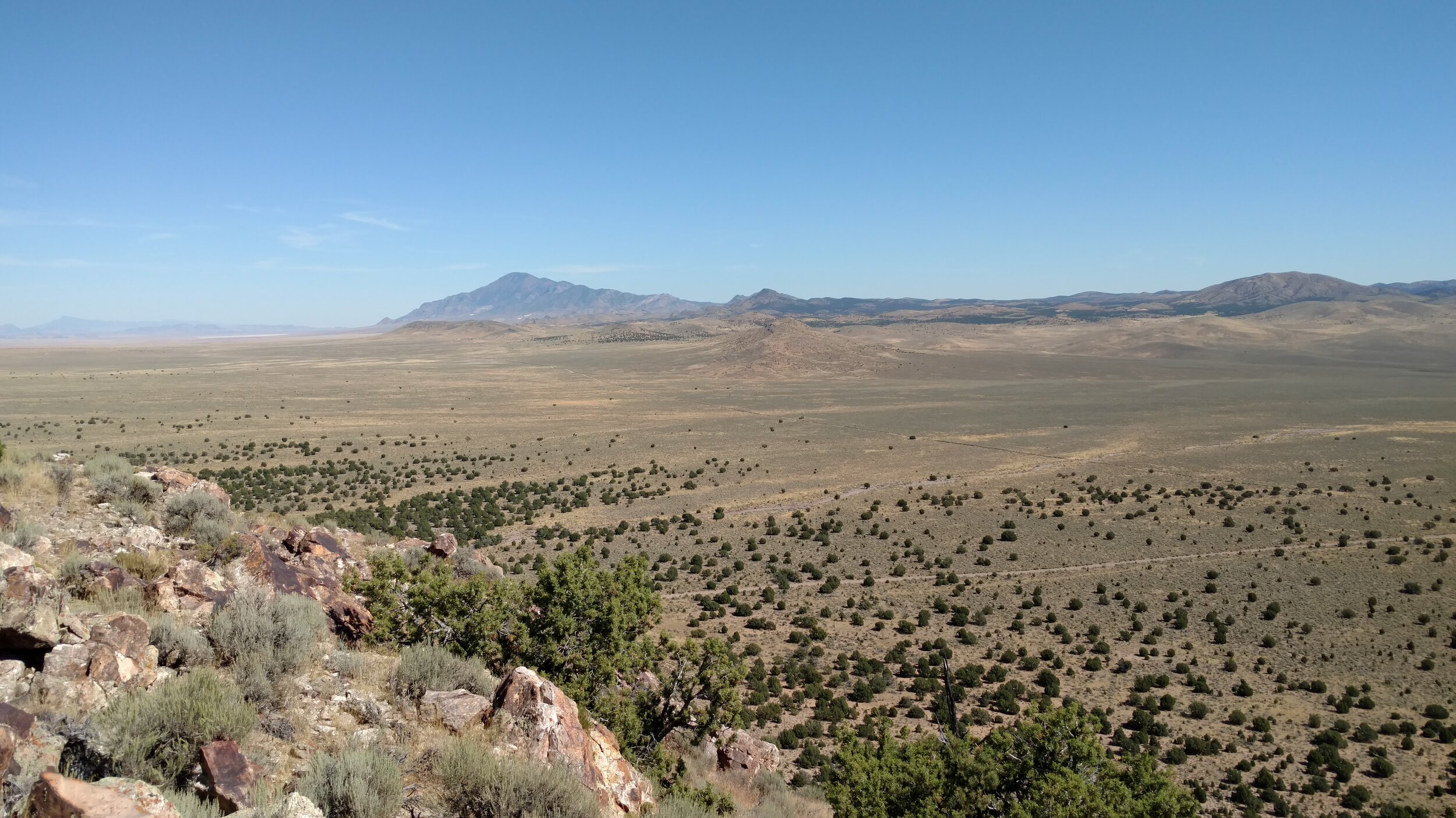
Peak 6139 Summit view north. Frisco Peak in the distance

Panorama from Frisco Peak (left) to Blue Mountain (right)
I eat lunch admiring the view, looking north the massive presence of Frisco Peak is in the distance. Frisco Peak is a drive-to-summit which I have yet to accomplish and contains radio towers at the peak. In a conversation with my 95-year-old father last week, we were discussing my hiking adventures in this area when he asked me if I knew of Frisco Peak and its location. I said I did and he told me he was one of the electricians who laid (climbed) the power poles to bring electricity to the summit towers. It was a fun story I had not heard before and now looking at the peak made me appreciate the difficulty of the task.
From this vantage point, I can also see my next summit. Peak 6010 is the brown mound laying in the forefront of the picture above. The road I'm currently using will lead directly to it on the western side. I have marked out a drive the leads to the eastern side and appears to be the better hiking option. I move off the long ridgeline of peak 6139 and back to my waiting jeep.

Road view of unnamed peak 6010; Beaver County; Frisco SW quadrangle; UT Rank 3539
I leave the main road and loop behind peak 6010 looking for another way heading south. I'm on a path that is not traveled often, and I miss the road leading south. After it becomes apparent that I missed the turnoff, I turn around and find an even less-traveled route. The tall, dry grass bothers me as it is evident this road has been traveled, but not very often. I finally find a spot of small sagebrush where there is very little grass to park and begin my hike up the side of the hill.
I'm parked directly below the center peak in this ridgeline grouping. It appears to be the highest point, but as I consult my GPS, I am surprised to find the southern ridge is the range highpoint.
Adjusting my heading, I aim for the high saddle between the two peaks. The southern (designated) summit has a cairn, but as I lay my GPS onto the ground, I only get a reading of 5,992 feet in elevation. From this vantage point, the middle peak appears higher. I know that's not a very good way to establish height, but it was worth a look as I hike back through the saddle and onto the middle summit. GPS now reads 6,010, and another small summit cairn exists. I sit down on the hard rock cap and look down the steep hillside to my jeep.

Fj waiting at the base of peak 6010
The middle peak is the higher of the two, but I don't worry too much about it. There is evidence of other ascents of this lonely peak, but not on any of the websites I use to research and record the mountains I have bagged. I'll make a note here and in my journal, but that will be the extent of it. Looking back along the ridgeline, peak 6139 sits at the forefront of more towering peaks yet to climb.

Unnamed peak 6139 appears to rise just beyond the designated summit of unnamed peak 6010