
Rain expected today. We are not quite sure what to do today with the rain expected in the forecast, so we slept in. Breakfast is served until 10:00 am and we had to hurry to be there with enough time to get something to eat. I guess that is what vacations are supposed to be, but as I refueled my body and looked out over Lake Wakatipu, I started to get excited for the day.
Out hike today will be relatively short and close by so we decided to drive to the Mount Crichton Loop track trailhead again. This time however, complete with rain gear, backpack cover, and additional snacks in the packs. We were on our way.
The loop is only a short 5 mile drive from Queenstown along the Glenorchy roadway. The trailhead is well signed and a large parking lot complete with bathroom awaits. We are the 3rd car in the lot. The sign indicates that this is a multi access trailhead with connecting paths to Twelve Mile Delta and Bob’s Cove. As we are getting ready to leave a couple hikes out and now there are only two cars in the lot.

Perhaps it’s the rain that has kept the crowds away or perhaps it’s the lack of knowledge about the loop, but it becomes obvious that we are going to spend a long lonely day hiking the path. It’s one of the advantages / disadvantages of the internet. Hidden gems can become overcrowded due to the world wide web. I’ve had a few trip reports that I’ve hesitated to write due the dilemma between providing beta and keeping someplace a secret. Mount Crichton is going to be one of the hesitant to write reports.
The trail soon connects with the alternate paths to Bob’s Cove and Twelve mile Delta, then turns right, up and across the highway. The engineers have done a good job in creating a crossing which gives the hiker lots of visible space in both directions. Not an easy feat on this twist and turn roadway.
Soon we reach the information board for the Mount Crichton Scenic Reserve. Here is where the loop completes. We choose to hike the trail in a clockwise fashion (which I would recommend). Cross the bridge and turn right. The trail follows the canyon with easy incline and decline along the canyon’s edge. This is a beautiful section of the hike, quickly becoming immersed into a deep forest of towering trees. The trail is very reminiscent of our experience on the Routeburn Track with two notable exceptions. First: we are a stone’s throw away from Queenstown. Two: we have not see another person on the trail.
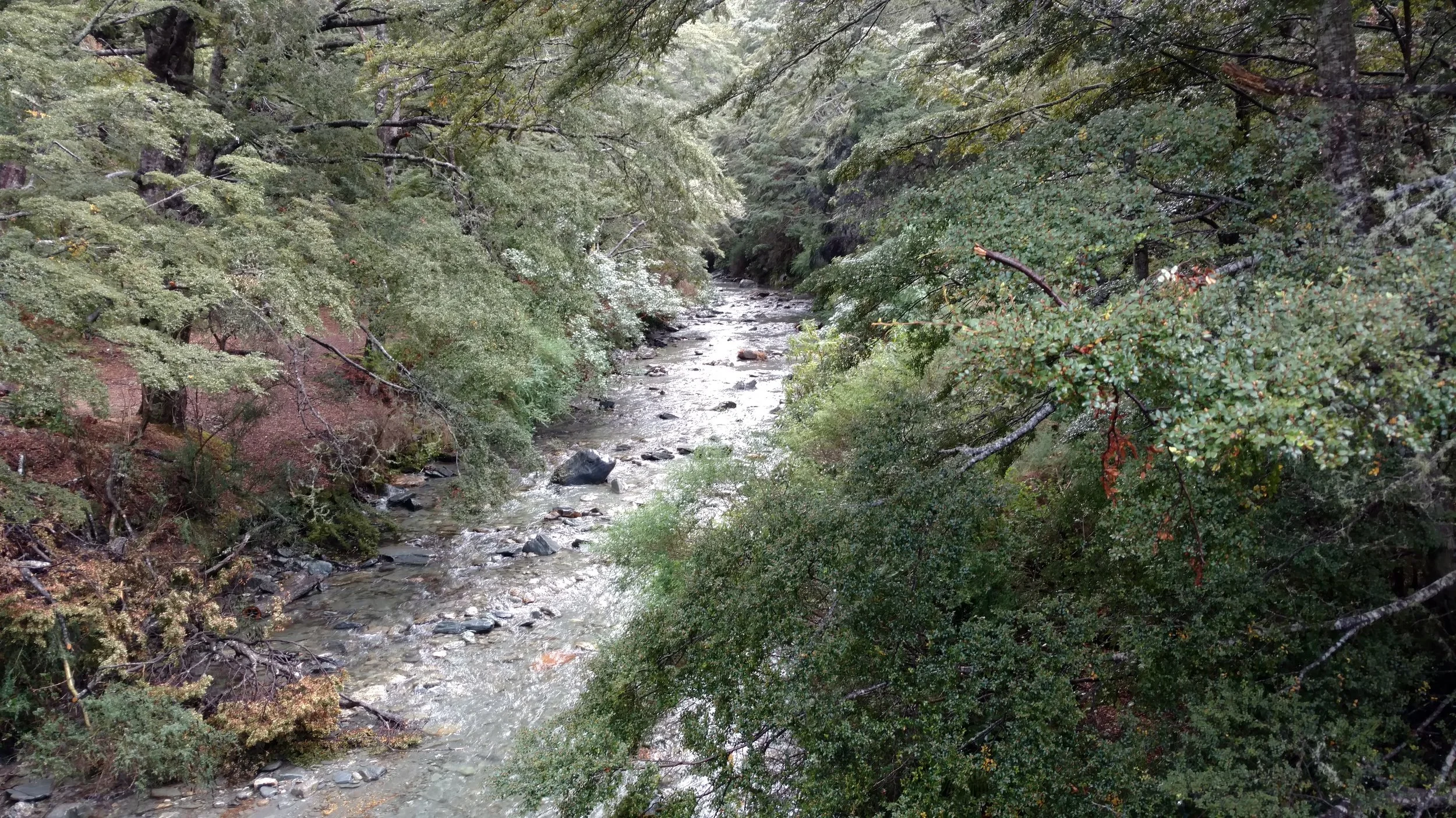
Trail view of canyon creek
It’s hard to explain a really nice hike to someone. Is it chance that we have the trail to ourselves? The gentle rain has stopped as we strip off our rain jackets and pack them away. Is it a mindset that the rugged beauty of this area strips away the stress of the world? It’s hard to say but one thing is for sure, you know it when you feel it.
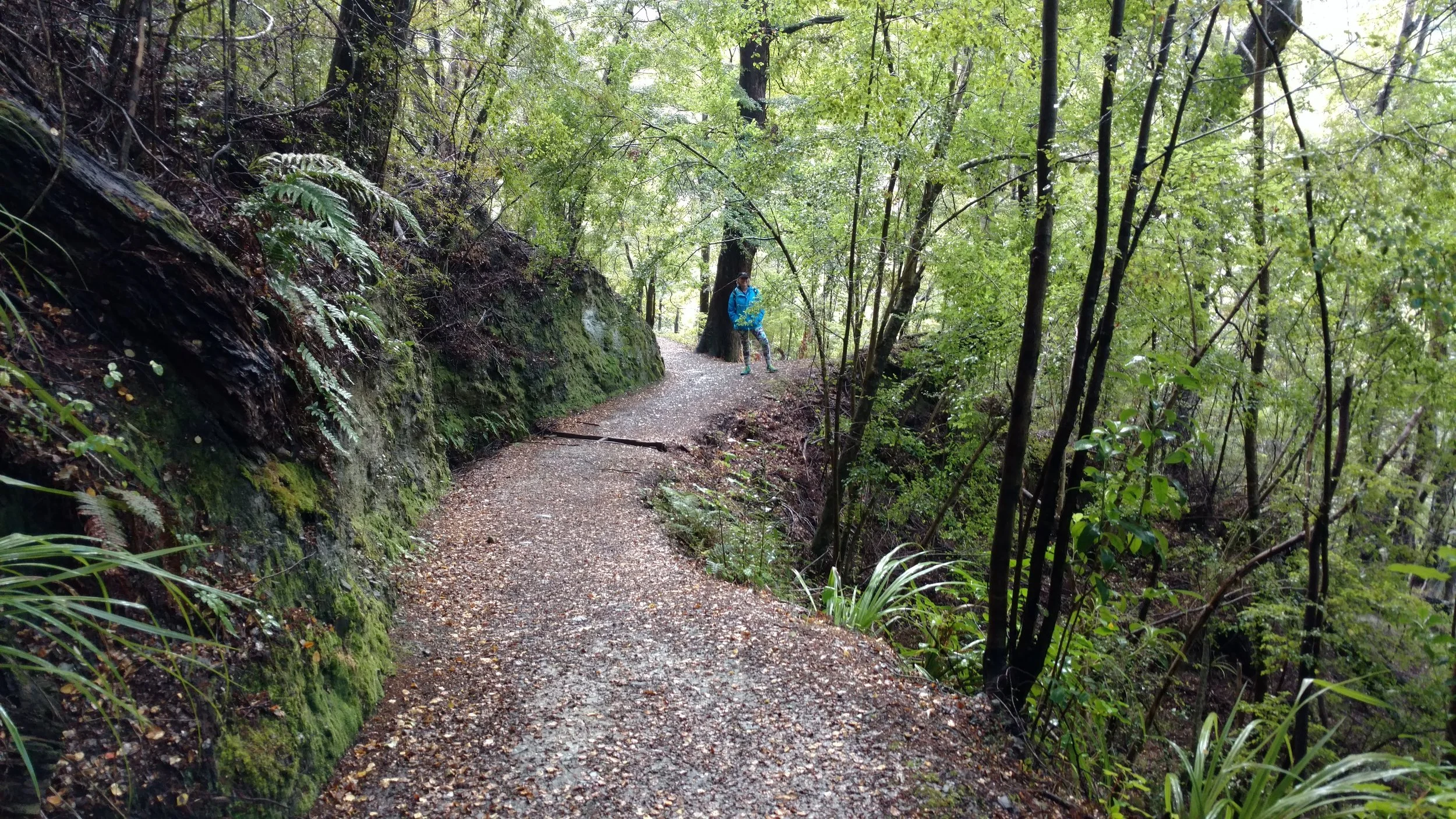
Linda hiking the loop
Hiking down a series of switchbacks we come to a side creek and another bridge. I take a few minutes to sit at waters edge while Linda looks for rocks. It is peaceful and quiet and I almost miss the first person to see today as he walks out onto the bridge. A trail runner to takes a moment to stretch before he begins running back the way he came. As we cross the bridge and start the next section of trail, It’s not hard to guess why her turned back. It is steep as we move to the higher section of the gorge.


Below the bridge, Linda looking for potential stones
Hiking up the trail we soon come upon a small valley with a massive composite hill. An information sign labels this as a mining site where it is estimated that miners removed as much as 1.8 million cubic meters of rock. A short 2 min detour leads to one of the coolest sections of the hike I’ve seen. A tunnel which was hand carved through solid rock to allow water and rock from the mining operation to flow into 12-mile creek.
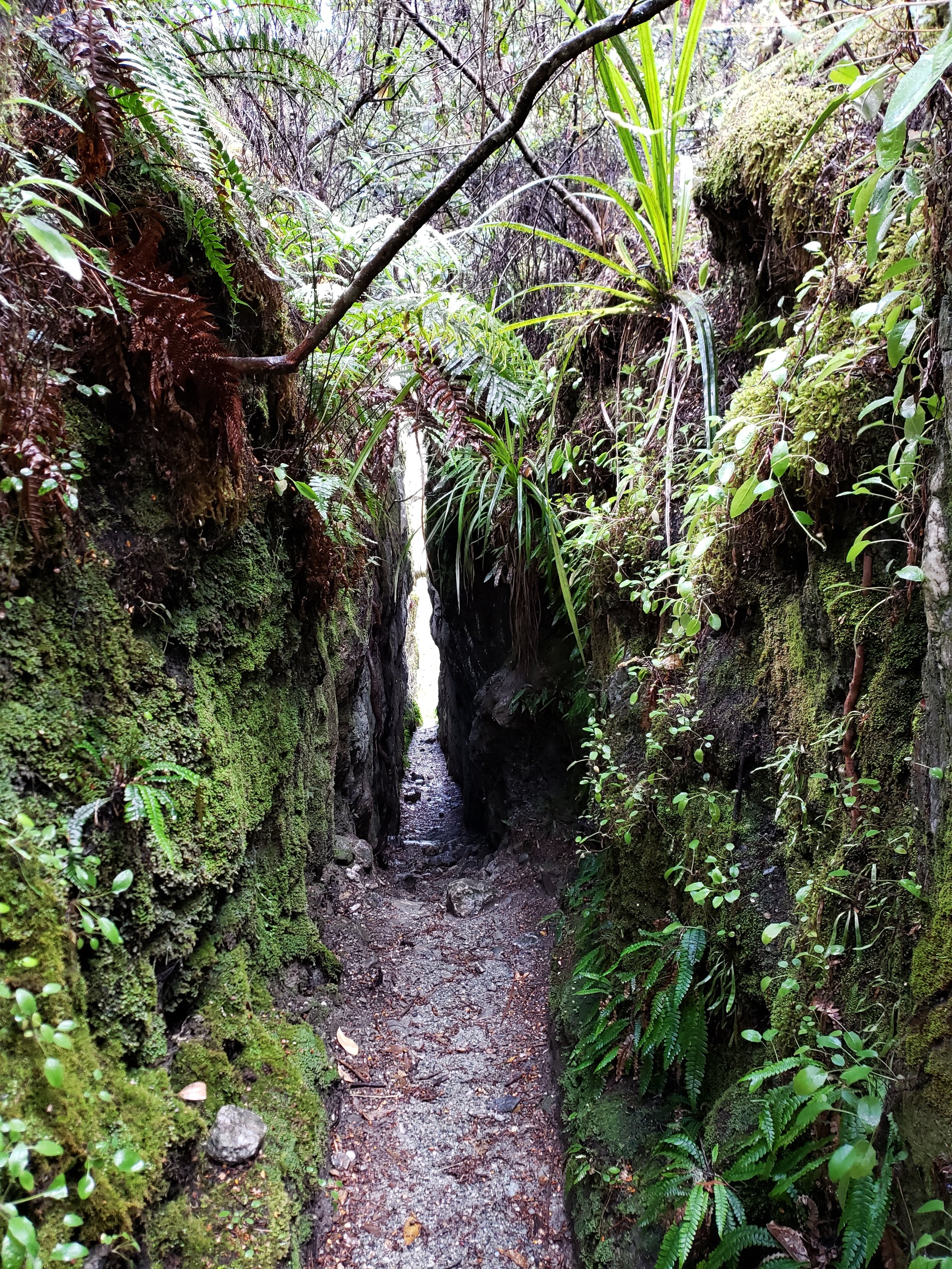
Tunnel
Tunnel is an inadequate description I think. Slot canyon is a better description. Tunnel is appropriate because of a small section near the middle that bridges the two slabs of rock. The walls are shoulder width apart as Linda and I make our way to the opposite side. It must have been painstaking to hammer, drill, blast this tunnel into being, but here it is and it is a stunning piece of dedication to the men who built it.

Why it’s called a tunnel not a canyon
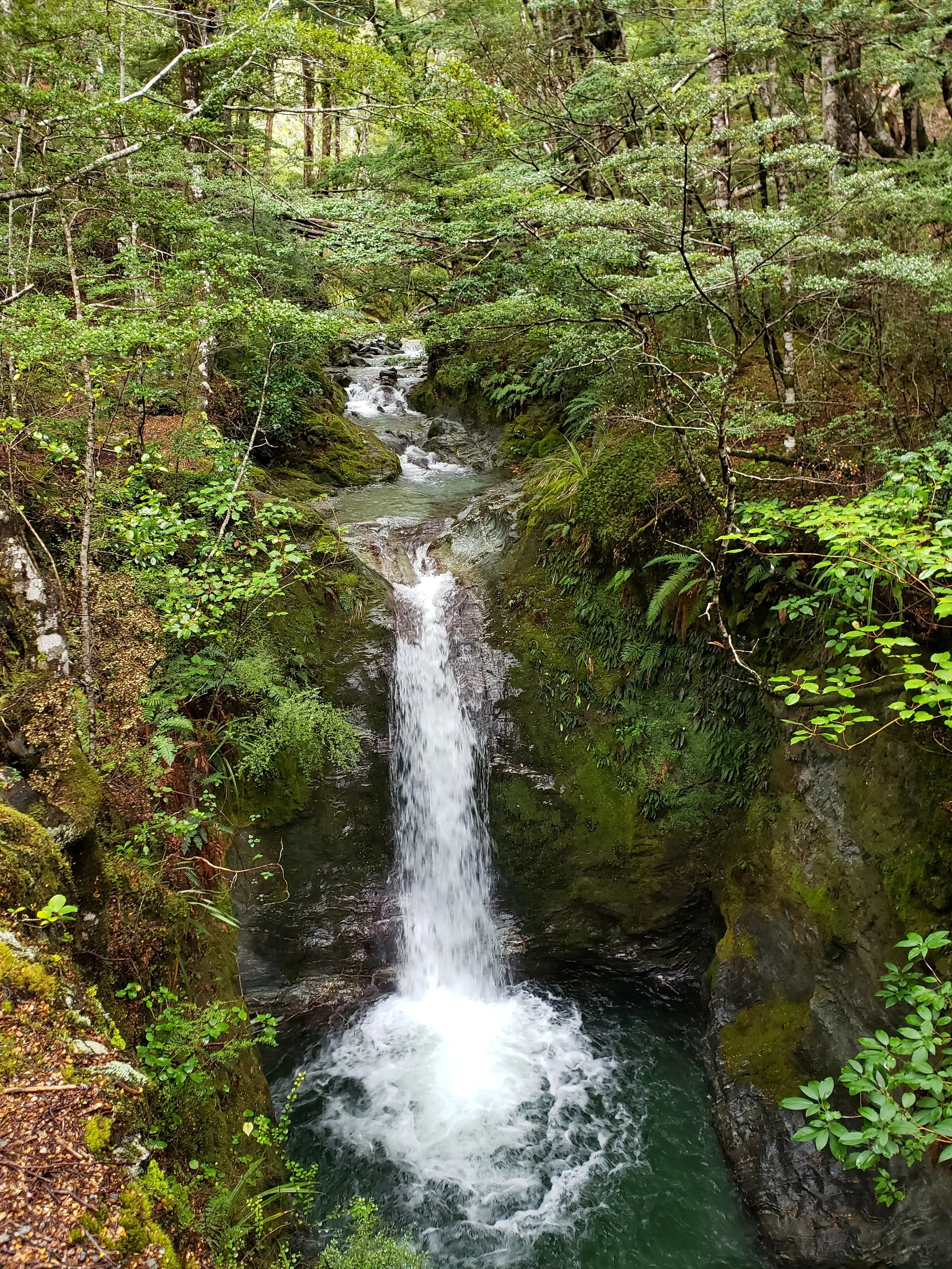
On the other side of the tunnel a small trail leads down to the river bed as Linda gathers a few more rocks. A stunning waterfall exists up stream but not wanting to get our feet wet we don’t approach it. A few more stones added to our growing collection and we hike back to the main trail.

Up stream waterfall
Next is Sam Summers hut; a wonderful information board describes this interesting individual who lived and mined the area. The cabin has been somewhat restored and a log book exists with several notations of spending the night. Personally I’d sleep in a tent outside, but that’s just me. **If not doing the entire loop this would be the place to turn around.

Sam Summers Hut

Sam Summers Hut
We cross the bridge behind the hut and marvel at the perfect waterfall bracketed by the canyon walls. The trail turns steep and begins the long climb toward the ridgeline.
Fairly non-descript as we hike through the trees following the trail’s switch backs. The ridgeline is a noted by a change in elevation as the trail first levels out and then begins to descend toward the lookout point. A distinct change can be noted. This is a black forest. It appears to be some kind of mold or blight, but it is amazing how absolute black the color is for something in nature. Along with the blight comes colorful mushrooms. This variety (Amanita muscaria - Mario Brothers, Alice in Wanderland) is common to the area as I’ve mentioned it before in the Ben Lomond trip report last year.
The viewpoint is stunning as the trail breaks to an opening allowing a view into the neighboring canyon and Lake Dispute. The massive Lake Wakatipu can also be seen as we sit on one of several wooden box benches to eat a snack.

Lake Dispute (picture bottom left) and Lake Wakatipu from trail viewpoint
Unfortunately, the wind and weather has picked up again so we don’t linger. Donning our rain jackets again we begin the 1 hour long gradual descent to complete the loop.
Walking along the track we are passed by a couple; the only people we have seen all day (+ trail runner), but before the end of the hour descent 6 more people would cross our path. Maybe this isn’t the hidden gem I thought it was, but having the trail to ourselves for the majority of our time here was as spectacular as our surroundings.